Planning Explained
What is a Planning Scheme?
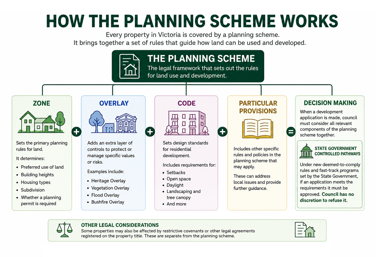
Every property in Victoria is covered by a planning scheme. A planning scheme is the legal document that controls how land may be used and developed. It contains zones, overlays and codes that councils use when assessing planning permit applications.
What is a Zone?
A zone sets the primary planning rules for land. It determines the preferred use of land, building heights, housing types, subdivision and whether a planning permit is required. Examples of zones are residential, mixed use (shops, offices and apartments) or commercial.
Most residential land in Boroondara is currently in either the:
- Neighbourhood Residential Zone (NRZ) – allows 1–2 storey dwellings. A planning permit is required for more than one dwelling and to subdivide the land. Other uses may be allowed such as medical centres.
- General Residential Zone (GRZ) – generally allows a wider range of housing, including townhouses and apartments up to 3 storeys.
Both NRZ and GRZ in Boroondara include objectives to retain the heritage and neighbourhood character of the area.
Land within Activity Centre catchments will be rezoned to the Housing Choice and Transport Zone (HCTZ). Its purpose is to facilitate a diversity of dwelling types and increase housing supply in well-located areas near public transport, jobs, and services. It is intended to provide a smooth transition from areas of higher density (core areas) to NRZ beyond its boundaries. There is no mention of character or heritage in the purpose or objectives of the HCTZ.
The new HCTZ was introduced to facilitate the Activity Centre changes and has two parts:
- HCTZ1 (inner catchment): up to 4 storey townhouses and apartments on any lot and up to 6 storeys on large lots.
- HCTZ2 (outer catchment): up to 3 storey townhouses and apartments on any lot and up to 4 storeys on large lots.
A large lot is generally defined as at least 1,000 m² with a 20 m frontage, encouraging lot consolidation.
To learn how the new zones are applied within Activity Centres, see The Victorian Government’s Housing Changes.
What is an Overlay?
An overlay is an additional planning control that applies to land with particular features or constraints, such as heritage significance, vegetation, flood risk or bushfire risk. It works alongside the underlying zone and may trigger the need for a planning permit or introduce additional assessment requirements.
When a planning application is assessed, both the zone and any relevant overlays must be considered. The zone provides the primary planning framework, while the overlay addresses a specific issue such as heritage or flooding.
Large areas of Boroondara are covered by Heritage Overlays.
What is a Code?
A code sets design standards for residential development such as setbacks, private open space, daylight, landscaping and tree canopy.
The Victorian Government prepares these codes and incorporates them into every planning scheme across Victoria. Councils do not write the codes. Councils assess planning applications against these State Government codes and must apply them when making planning decisions.
The new residential codes replacing ResCode are:
- Townhouse and Low-Rise Code (Clause 55) – developments up to 3 storeys.
- Mid-Rise Code (Clause 57) – developments of 4–6 storeys.
These codes apply across Victoria, regardless of the underlying zone.
For more information about these new codes, see The Victorian Government’s Housing Changes.
How do they work together?
Imagine a developer proposes a 4-storey apartment building on land within a HCTZ which is a walkable catchment associated with an Activity Centre.
- A planning permit is required as there will be more than one dwelling.
- The zone determines that a 4-storey building may be permitted.
- If in HCTZ1, the land could be any size lot.
- If in HCTZ2, the lot must be at least 1,ooo sqm with a 20m frontage (after consolidation).
- The Mid-Rise Code is a deemed-to-comply code that sets standards for setbacks, open space, landscaping, daylight and other design requirements. Setbacks are prescribed and do not need to match those of other homes in the street. The fourth storey will not need to be recessed and lot coverage can be 70% with 10% tree canopy requirement. The impact on neighbouring solar panel installations does not need to be assessed. See: Mid-Rise Code
- Objections are effectively limited to whether the measurements comply with the code. If compliant then council must issue a permit. The community has no right to have the decision reviewed at VCAT. If a specific standard is not deemed to comply then the right to go to VCAT exists but is limited to that standard only.
- If the land is covered by a Heritage Overlay, heritage policy is a further consideration. The impact of the development upon the heritage significance of a neighbouring Individually Significant home or the streetscape will be assessed. The community has the normal right to object and go to VCAT on heritage grounds.
- If the development is considered to not respect the heritage values then the council is required to balance the objectives of the zone (density, diversity and transition from high to low density) against the requirement to respect the heritage values. There is not yet any guidance or VCAT / Supreme Court precedent on how to undertake this balance.
To learn how the new planning reforms may affect these areas, visit Heritage at Risk.
What are the planning approval pathways?
Traditionally, councils assessed planning applications using performance-based standards and exercised judgement when balancing competing planning objectives. Neighbours were generally notified of applications, could lodge objections, and both applicants and objectors usually had the right to seek a review at VCAT.
Under the new deemed to comply pathways, if a proposal meets the prescribed standards in the relevant Code, council must issue a planning permit. Residents’ rights to object and seek VCAT review are also more limited than under the previous system.
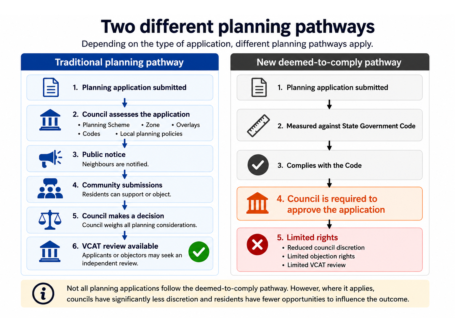
For more information about how the new Codes affect residents’ rights and council decision-making, see Democratic planning x.
What are restrictive covenants?
Some properties are also affected by restrictive covenants. These are private legal agreements registered on a property’s title and are separate from the planning system. A restrictive covenant may limit what can be built even where the planning scheme would otherwise allow development.
For example, a covenant may prohibit more than one dwelling on a lot, restrict where a building can be located, limit the type or height of buildings, or prohibit certain land uses.
Whether a covenant can be changed or removed depends on the circumstances and is a legal rather than a planning matter.
Not all properties are affected by restrictive covenants. They can usually be identified by searching the property’s Certificate of Title.