Camberwell Junction
Boroondara Council had adopted the Camberwell Junction Structure and Place Plan and seeking the Minister for Planning’s approval to incorporate it into the Boroondara Planning Scheme when the Victorian Government announced its plan for the ‘core’ at Camberwell Junction. Two years of strategic work on enhancing the centre – rather than simply defining heights and setbacks – and three levels of community consultation – had been undertaken, as per Government direction.
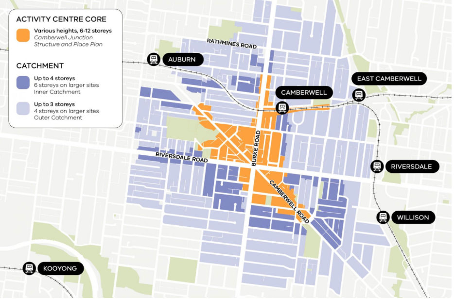
The Victorian Government adopted the heights and boundary for the core proposed by Boroondara Council and introduced a catchment. Rather than measure the 800m / 10 minute walkable catchment from the train station or even where Camberwell, Burke and Riversdale Roads meet as would have been expected, it used the extremities of the area council had identified. Hence the catchment is significantly larger than it ought to be.
The Victorian Government has refused to release the traffic, drainage and infrastructure assessments it undertook despite requests by a Parliamentary Inquiry and Notices of Motion in the Legislative Council.
The Camberwell Junction 10 minute Density Zones (walkable catchments)
In addition, large surrounding residential streets (Catchment Areas) now allow up to 6 storey development.
- The addition of 3-6 storey apartments in a catchment zone was not supported by Boroondara Council.
- The area includes 10,800 dwellings of which 4,500 are heritage protected.
- Analysis of the implications for transport, drainage community infrastructure (roads crossings, street
furniture) has not been released by the Victorian Government - public open space assessments, schools, health services, library, maternal health and sewage systems
critical to sustainable community wellbeing have not been undertaken - No public, social or affordable housing targets are included
- No meaningful Council nor community consultation was conducted
By expanding the core area beyond the shopping strip between the Junction (of Burke,
Camberwell and Riversdale Roads) and the station the 10 minute walkable zone
extends up to a 20 minute walk.
The zone affects 26 Heritage Precincts, approximately 4,500 heritage homes.
Many of the recommendations by the expert advisory committee the Minister for Planning convened
were not implemented. Had they been:
- the rezoning of catchments would not have occurred
- the core would have been substantially smaller and by extension the catchment smaller
- the 10 minute walkable criteria would have been consistently applied from Burke Road
- heritage precincts would have been excluded from the catchment
The Government claims that it “listened to community feedback”. BCG considers that the consultation
process was performative, a “tick-the-box” exercise. Not one of over 4,000 community responses was referred
to the advisory committee. Amendments to the catchments were “tweaks” at the edges that mostly
responded to the need to define boundaries clearly. One concession was that the heritage precincts close to
the core were not zoned for 4-6 storeys.